Sunday, August 26, 2007

The Thicket

On June 3, 1850 in Inferior Court of Gordon County, Georgia Oothcaloga Depot was named the county seat of Gordon County. The fact that Oothcaloga Depot won the honor over Big Springs can be attributed to the philanthropy of John P. King. Mr. King graciously donated all of the land that was going to be used for public buildings. He also donated a strip of about thirty acres of piney woods. These woods separated the growing hamlet around the Depot from Oothcaloga Creek and a millpond. These bodies of water, in alignment with the scientific thought of the day, were believed to be the source of the “bad air’ that was thought to the causative agent of malaria.

It is said that the Gordon County Fairgrounds adjoined the pine thicket in southwest Calhoun. This is confirmed by the 1911 Sanborn Tax map in which the “Pine Grove” was noted as being east of West Pine Street. From what I can tell, West Pine Street approximates the route of present day Yellow Jacket St.

In the picture the red line approximates the Oothcaloga Street. This street extended out toward the Rome road. The green colored area is thought to be the “Thicket”
Tuesday, August 21, 2007

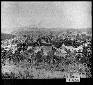
Looking West, 1916


This photograph from 1916 is described as an aerial view from atop Mount Alto.

Thursday, August 16, 2007

Johnson Gin Company, Between 1911 and 1943


The picture above is of Johnson Gin Company. The business was located at the corner of South King and Court Street. This company appears on the 1911 Sanborn Fire Insurance Map for Calhoun. It was destroyed by fire in 1943.


Wednesday, August 15, 2007

Information about Unknown Landmark

I learned today that there was a reservoir atop of Mt. Alto at one time. Could this be a man made oval shaped reservoir? I also may have a lead on the house in front of the structure.
Tonight I discovered digitalized 1911 tax maps for Calhoun on the Internet. There is a road on one of these maps named O'Calligan Road. This road is labeled as leading to the "Reservoir". This road appears to start directly across Piedmont from North Court Street. I think that O'Calligan is the alley that leads to the parking lot the Calhoun Municipal building. I visited this parking area Thursday afternoon and discovered that there is an iron pipe jutting out of the bank above this parking lot. The 1911 map indicates that an eight inch pipe followed O' Calligan to the "Reservoir".

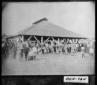
Pavilion Park, ca 1897


The photograph is said to be taken by T.F. Tomlinson in 1897. The band in the photograph was know as the Belmont Band. There are several photographs of this band in the Vanishing Georgia collection. However, this post is about the Pavilion. The citation with his photograph states that this Pavilion was located at the site of Phil Reeve Stadium. The Reeve is the home of the Calhoun High School Yellow Jacket football team. Considering that I am one of the administrators at CHS I had to give us a plug. Back to the Pavilion! There is no landmarks of any type to mark the location of this part of Calhoun history that has vanished. Maybe somebody that reads this blog can shed some light on the history of the pavilion.

Monday, August 13, 2007

Unknown Landmark in Calhoun, Georgia


This home in the middle of the photograph is the Boston House or Mt. Alto. ( ca. 1939) It was the home of Dr. John H. Boston. Dr. Boston is a notable Calhoun figure. However, this post is about the odd structure behind the house in the upper right hand corner of the picture? Any ideas about what we are looking at? You can double click on the picture and it should open in Explorer.